Where it runs
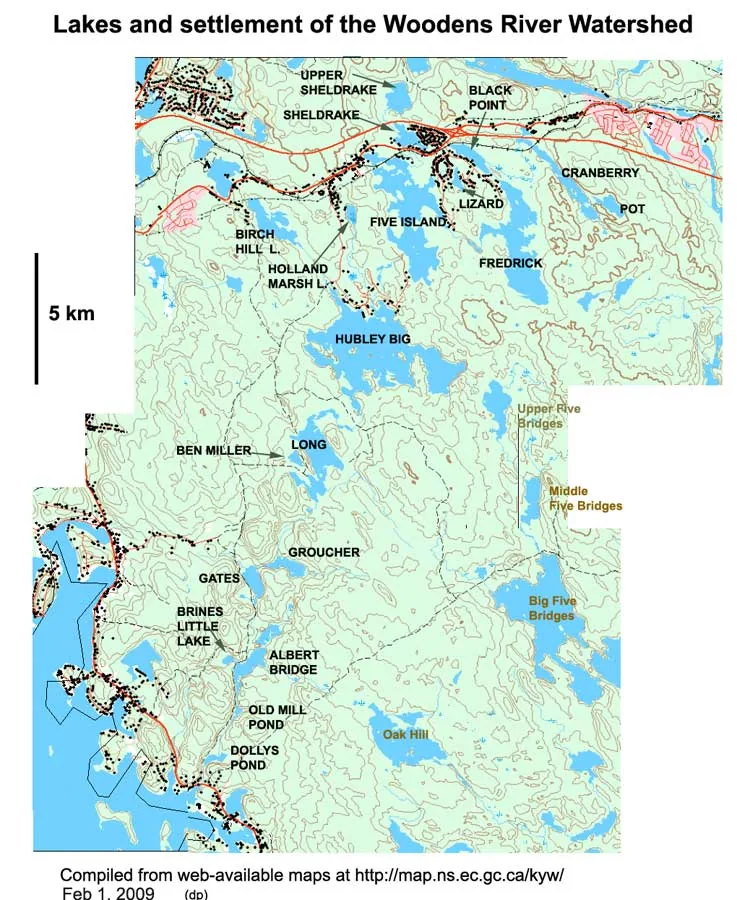
The Woodens River watershed includes all land, habitations and streams that drain into the Woodens River system. The headwaters lie in the region of the Hubley exit (Exit 4) on Highway 103, twenty kilometres west of peninsular Halifax. From there a set of 19 connected lakes flows southwest across the Chebucto Peninsula into the Woodens River and finally into St. Margaret's Bay at Woodens Cove in Seabright, a distance of roughly 20 km. The total area is about 65 km².
The lakes include Upper and Lower Sheldrake, Frederick, Five Island, Hubley Big, Cranberry, Black Point, Birch Hill, Long, Croucher and Albert Bridge. The watershed takes in large tracts of close-to-pristine wilderness as well as recent and older settlement, and holding those two realities together in the same watershed has always been the work of this organization.
Upper, central and lower
The upper watershed holds several residential communities with access to the city along Highway 103. Relatively high-density lakeshore development near the headwaters has had a significant adverse effect on water quality in the upper lakes.
The central watershed is a tract of Crown land surrounding Hubley Big Lake, Long Lake and Croucher Lake, only sparsely populated. Lakes downstream of Hubley Big have not been seriously affected as yet.
The lower watershed holds forestry land on both sides of the Woodens River, and residential settlement along the coastal portion of Highway 103 from French Village past Seabright toward Peggy's Cove. Failure to comply with harvesting regulations in some earlier logging operations destroyed natural buffer zones along parts of the river bank in this region.
The challenges
Many of the lakes and streams remain relatively pristine and support brook trout populations. Some of those closer to the sea support alewife and American eel. Residents and visitors alike value these watercourses and wetlands and want to preserve their beauty and health. That heritage is under several kinds of environmental stress:
- Existing settlement and roads in critical areas of the watershed
- Ongoing development pressure
- Logging
- Acid rain
- Climate change
- Recreational activities
An unexplained collapse
The Woodens River watershed — but not the other watersheds in the area — was subjected to a severe stress of some kind in 1989–90, when the early mayfly hatch declined suddenly and precipitously. It remains unexplained. The mayflies have not recovered to their glory days, and neither have the trout, although there have been sporadic reports of some recovery.
Water quality
Water quality refers to the physical, chemical and biological characteristics of water, measured against the needs of the organisms that live in it or drink it. In an environmental context the highest water quality is the water found in pristine environments. For the Woodens River system that water is typically somewhat acidic, nutrient-poor, and high in humic acids, which colour it brown. Maintaining that brown water matters: it is a large part of what protects trout from the effects of acid rain, and it depends on the integrity of the land-water system as a whole.
WRWEO has been especially fortunate in the volunteer services of Bob Chambers, who over more than a decade conducted careful, extensive and intensive monitoring of key limnological variables on a number of lakes in this watershed. His study of water quality parameters — phosphorus, pH, dissolved oxygen — in the upper lakes across the period 2000–2010 produced a large database, covering Cranberry, Black Point, Frederick, Five Island, Hubley Big, Long, Sheldrake and Birch Hill Lakes. His reports and the wider water quality literature are collected under reports, maps & links.
Fish and fish habitat
The Woodens River system is a catch-and-release Special Trout Management Area. Birch Hill, Blueberry, East Duck, Five Island (and Five Island Lake Run), Frederick, Holland Marsh, Hubley Big, Jacket, Lizard and Sheldrake Lakes, and the Woodens River downstream from the outflow of Hubley Big Lake including all lakes and tributaries, are catch and release only. Single hook lure or artificial fly; natural bait is prohibited. Confirm the current rules in the provincial angler's handbook before you fish.
Five Island Lake was contaminated by PCBs in the mid-1990s. WRWEO was represented from 1995 to 2004 in monthly meetings of the Five Island Lake Citizens' Liaison Committee, which worked with the province to address the spill in the north bay of the lake. By 2008, PCB concentrations had fallen to levels considered non-toxic to humans and wildlife.
In 2000, an aquatic survey of the streams feeding the Woodens River employed three young people over a summer to carry out baseline habitat and water quality studies across the watershed. In 1998, an extensive physical survey collected more than 6,000 data points through the Youth Conservation Corporation. Both projects were initiated and supervised by WRWEO.
The Sheldrake Lake aeration project
The deeper part of a lake — the hypolimnion — can become oxygen-depleted in summer, through natural processes or as a result of human disturbance. Those deep, cool waters are where brook trout take refuge in the heat, and trout need oxygen, so deep-water depletion eliminates important habitat. Surveys of the upper Woodens River watershed showed that several lakes become oxygen-depleted at depth over the summer.
Mechanical aeration systems are used to aerate deep water that has lost its oxygen, a common practice in Europe and parts of North America. The aeration has to be gentle, so as not to disturb the stratification that keeps the deep water cool in the first place.
WRWEO volunteers fundraised more than $40,000 and in 2003–04 constructed the first lake aeration system in Nova Scotia, installed on Sheldrake Lake. In 2007 the Sheldrake Homeowners Association took over responsibility for maintaining it, with ongoing support from WRWEO. Detailed monitoring by Bob Chambers in 2009 found the system was not working effectively, though there was some indication that phosphorus levels had declined. Possible improvements have been discussed with the homeowners association. If the approach can be made to work, it has implications for a large number of lakes in Nova Scotia.
Working towards solutions
Much of the watershed is Crown land, and a good deal of the private land is undeveloped or minimally developed, held in a close-to-pristine state by owners who value it for wilderness recreation. WRWEO's main reason for existence is protection of this watershed. The major activities have been:
- Creating The Bluff Trail, to introduce people to a portion of the wilderness in a tread-lightly context
- Seeking wilderness protection for all public land on the Chebucto Peninsula between Highways 103 and 333 — now the Five Bridge Lakes Wilderness Area
- Constructing the first lake aeration facility in Nova Scotia
- Monitoring limnological variables across the upper lakes
- Compiling every study and document we can find about this system, and publishing them
Since 2012, WRWEO has also worked with other local groups in a water quality committee led by the St. Margaret's Bay Stewardship Association, creating and implementing a stewardship plan for the watersheds flowing into St. Margaret's Bay.
These are ongoing activities, and we are working towards a long-term watershed management plan. The first one was written in 1998.